Racers and volunteers from across North America spent a week of spirited racing along with the camaraderie that the regatta is known for.
Although Pointe-Claire Yacht Club has some shallow water surrounding it, getting in or out is easy if you know what to look for.
PCYC is located on Lac St. Louis, and like the other lakes along the St. Lawrence River between Kingston and Quebec City (such as Lac St. Francois or Lac St. Pierre) it contains large shallow areas that can be a hazard to sailors. This becomes more evident with lower water levels.
But approaching or leaving the club is not difficult if the correct procedure is followed. There is ample depth around the public launch dock and entrance to the club, and from this area, there is a clear path out into the deep water of the lake. PCYC maintains two range marks in the form of two diamond-shaped, yellow signs, one above the other, each bisected by a vertical black line. When these two marks are lined up, this indicates that a boat is on the safe channel (following the range) to come in or go out. This is the range line.
The marks are lighted with non-flashing green lights that can be lined up as well. In this image, the lower sign is to the left, and so the safe line would be more to the left. The range line going in is at a heading of 130 degrees (true), 310 going out, and roughly points out to the lighted, red channel marker AD20. (Note that the channel marker is taken out in the spring and fall, and so there may be times when it is not there.)
It is important to follow the line, because there is shallow water on either side.
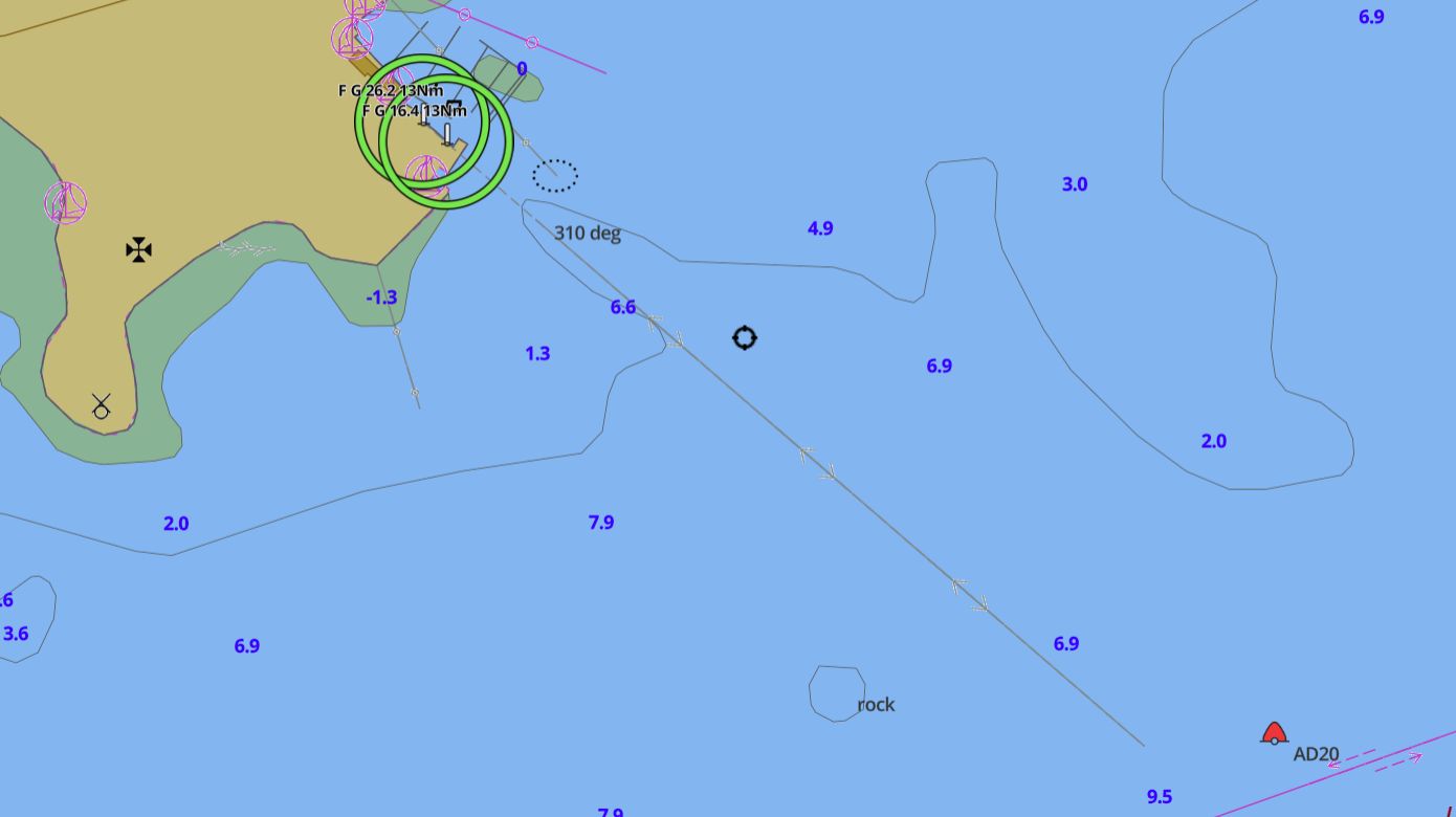
Just southeast of the range marks (large green circles) you can see an obstruction. This is marked by a yellow buoy. It is safe to pass on either side of this buoy, but it is important not to go west of the range line near shore, nor to go too far east or northeast of the range line further out as both areas are shallow, and boats have been hitting rocks, sunken vehicles, and who knows what else in these areas since the founding of the club. Transport Canada requires that all boaters either have a chart (electronic or paper) on board or sufficient local knowledge. It’s always a good idea to have a chart for the area. The paper one is No. 1430 – Lac Saint-Louis.